STATUS UPDATE: This study is now complete: Imagine Nicholasville Road was adopted as a part of the city’s comprehensive plan, Imagine Lexington, on May 20, 2021. Information from the city regarding this plan/study can be found at the following link: https://imaginelexington.com/imagine-nicholasville-road.
Here is a link to the Imagine Nicholasville Road Public Hearing via Zoom on May 20, 2021. (Starts at 20:23).
What follows below is an historical summary of the study (posted in 2020) as it relates to our neighborhood:
Lexington’s new Comprehensive Plan, adopted in 2019, calls for the incremental densification of the major road corridors into and out of Lexington.
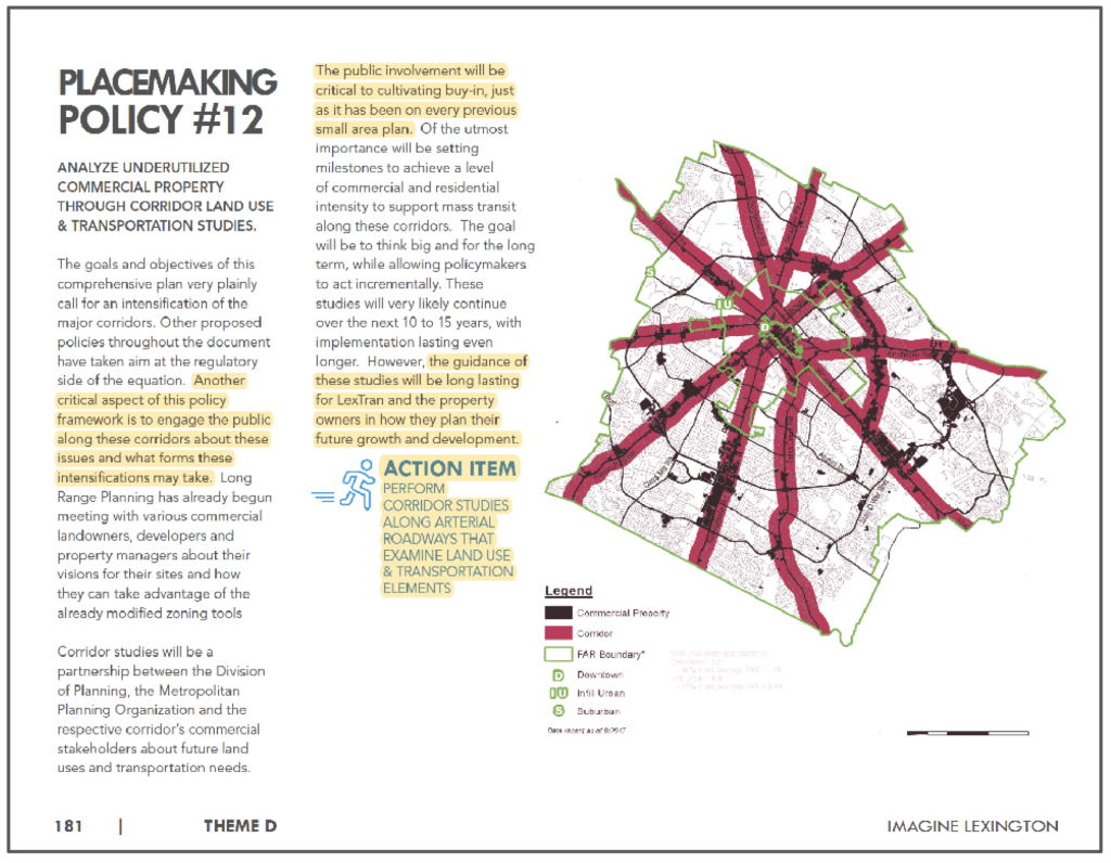
This densification, in turn, requires the need for a comprehensive corridor plan. The 2019 US 27 / Nicholasville Road Coordinated Land Use Plan and Transportation Study is designed to meet that need and serve as a prototype for future corridor studies.
The SHNA decided to dedicate one of our web pages to this important study due to the inevitable impact on our neighborhood. Funded in November 2019 for $222,000, this study has been recently publicized as “Imagine Nicholasville Road.” It began with a kick-off in November of 2019 and is scheduled to conclude with final products delivered by December 31, 2020. Facilitating public and stakeholder engagement is one of the stated purposes of the project, and neighborhoods adjacent to the corridor are listed second among the Key Stakeholders.

The study area runs along Nicholasville Road from Vine Street downtown to Brannon Crossing in the south, and includes a 1/2 mile buffer along the corridor on either side. This puts one half of our neighborhood within the actual study area, from Hiltonia south to Edgemoor, and to the east just beyond Wildwood.
As of Sep 17, 2020, there are no links to this study found on the Planning Commission website under “Plans, studies, and surveys,” or the Lexington area Metropolitan Planning Organization (MPO) website under “Projects” or “Studies and Plans.” [This is still true as of Dec 29, 2021]. This is one of the reasons we created this page, to provide more details that are publicly lacking online. The newly launched “Imagine Nicholasville Road” website is incomplete at this time [As of May 2021, It is now complete and can be reference here ], and incorrectly lists the study start date as “Winter of 2020” (We believe this may just be a typo). You may, however, sign up for public engagement on that site. Details and a link to the “Imagine Nicholasville Road” public engagement page are at the bottom of this blog post. We encourage all of our neighbors to subscribe to the Imagine Nicholasville Road page for updates and to attend any announced upcoming meetings.
At the request of our attorney, and because the publicly available information was so sparse, we were provided a copy of the signed agreement for the services contract for the study. It includes the winning proposal and lays out the scope and nature of the study and demonstrates an awareness of the resulting corridor plan’s impact to adjacent neighborhoods. Specific tasks are listed along with a proposed schedule of those tasks and a timeline for final products. Please review the contract and familiarize yourself with the particulars of the study. This will help us have more informed engagement as the study continues.
Link to the Executed Consultant Services Agreement.pdf
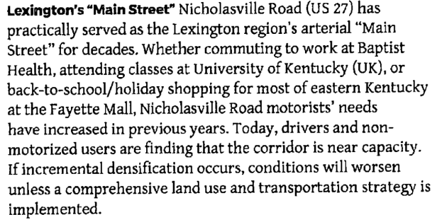
This study is unique in that it combines transportation with land use planning (zoning), and it’s findings will shape and inform development along the Nicholasville Corridor and will directly impact our Neighborhood. A prior Lextran 2014 study of Nicholasville Road involved alternative analysis of transportation along the Corridor and recommended implementing a Bus Rapid Transit (BRT) system. BRT is sort of a “light rail” system without the rails (see 2014 study link at bottom of page).
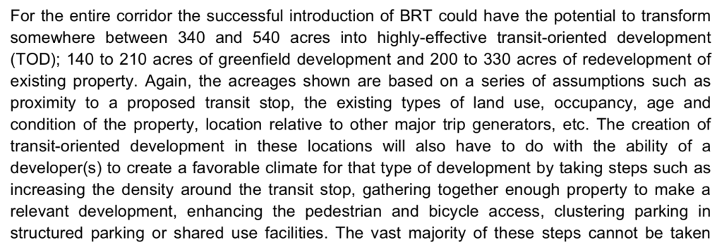

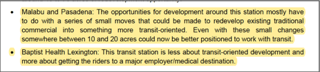
More intense development is recommended around the BRT station stops. This is known as transit-oriented development (TOD). In the 2014 study, the two proposed BRT transit stations nearest to Southern Heights are at Malabu and Pasadena and at Baptist Health, although the Baptist Health transit station is not a focus for transit-oriented development.
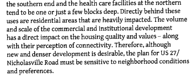
It is important to note that our segment of Nicholasville Road from Hiltonia to Edgemoor is also NOT identified as an area with potential for infill redevelopment in the 2014 study, unlike the commercial areas south of Southland Drive toward New Circle Road:

In order for BRT to become a reality alongside the Comp Plan stated goal of densification along the corridors, the need for the current study was born — “as a prototype for developing a comprehensive transportation and land use corridor plan.” A plan that will have a “detailed regulatory framework” for implementation “including site-specific land use recommendations and corridor-based design guidelines and/or standards.” These stated goals will impact the future of our Neighborhood, and it is important that we inform ourselves about all of the aspects of this study and make note of our preferences regarding the outcome.
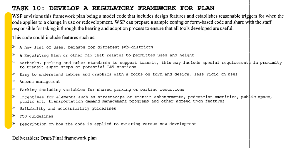
We feel that all zone change requests in the area of our neighborhood along the corridor would be premature until this study is complete. A regulatory framework including a “corridor overlay” that could be adopted as a component of the current Comprehensive Plan and “design guidelines and standards” for what development along the corridor should look like are expected products of this study. Also note potential form-based code features listed under Task 10 in the Amended Scope of Work below, and how those might impact current land use decisions.
We also feel that secured funding and a project timeline for transit infrastructure improvements should be in place before more intensive zoning uses are approved.
It’s a lot to take in. The new Comprehensive Plan is over 300 pages long, and along with the Placebuilder section it represents a change from a traditional future land-use map plan to a policy-driven one. All of the lingo and terminology are new and confusing to us and it has been quite challenging and time consuming to digest the new Comp Plan as well as all of the Corridor study information. We are tasked with trying to engage in a process that feels like traveling in a foreign land — but not as fun. Our Neighborhood sits at the nexus of a perfect storm. Our current low-density residential zone is in direct conflict with the increase density recommended along the corridors. Knowing that the land uses along a corridor should not be determined by a “one size fits all” approach, and that the mission to protect the character of established, successful neighborhoods included in the Comp Plan is a significant one, our hope is that the framework formed by this study will be respectful of the context and human scale of our nearly 100 year-old community. Another way to look at it would be to determine what impact our low-density residential neighborhood has had on the corridor? What is our symbiotic relationship with the corridor’s economic development? We have evolved together over 98 years and we are still thriving. This indicates to me that our current zoning is appropriate for our small portion of the corridor. It’s just right. The right amount of density at the right spot along a well-traveled road.
Thank you for your time and attention on this matter. We will be adding more to this page as we learn more.
What follows are links to reference materials related to the study:
June 26, 2019 – Introduced to Transportation Policy Committee
Video Link 12 min video clip of the meeting. The first 8 mins describe the study Purposes and Tasks, Goals and Objectives.
June 2019 – A request for proposal (RFP No. 27-2019) was advertised on the American Planning Association website with a submittal deadline of July 23, 2019.
November 14, 2019 – Lexington Urban County Council Meeting resolution – “A resolution authorizing and directing the Mayor, on behalf of the Urban County Government, to execute a Consultant Services Agreement with WSP USA, Inc., for the completion of the U.S. 27/Nicholasville Rd. Coordinated Corridor Land Use Plan and Transportation Study, In response to RFP No. 27-2019, at a cost not to exceed $220,000.”
Link to Study Contract (same as link the the “executed services agreement” above)
Imagine Nicholasville Road links:
Imagine Nicholasville Road Open House on March 4 at Lex Green
Imagine Nicholasville Road website launched in Feb 2020
Relevant studies (More will be added as time permits):
